GTA 6 map: interactive map of Leonida
718 pins in 24 layers · Updated
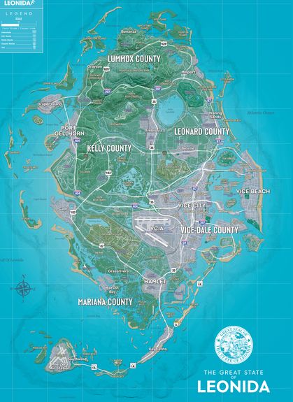
This is every place in Leonida we know of on one map: 69 places we track ourselves and 654 landmarks mapped by the GTA VI Mapping Community, 363 of them with an in-game photo. Switch layers on and off in the panel (on phones, tap Layers & search), search for a place, and tap a pin for its card and page. Places we only know roughly show a dashed circle around their pin when you open it.
How big is the GTA 6 map? About 175 km² by PowerPyx's measure of the finished game, and about a third of it is water. More in how big is the GTA 6 map. What regions are in GTA 6? Six that Rockstar named: Vice City, Leonida Keys, Grassrivers, Port Gellhorn, Ambrosia and Mount Kalaga National Park. The game splits them into five counties, Vice-Dale, Mariana, Leonard, Kelly and Lummox, explained on our Leonida page.
The base map is Rockstar's official printable Leonida map, out on 19 November. Use the Community button for the community map by YANIS and the GTA VI Mapping Community, which has street names. Your choice is remembered on this device. Found a place we're missing? Right-click or long-press the spot, copy the link and post it on the Places board.
Regions, north to south
Map layers
Each layer has its own page with every location in it. Busy layers (buildings, bridges and utilities) start switched off on the map.
GTA 6 map FAQ
- Is there an official GTA 6 map?
- Yes. Rockstar published a free printable map of Leonida on its GTA VI downloads page on 19 November 2026, launch day. It's the default base map here, with every pin lined up on it. The Community button switches to the community map drawn by YANIS and the GTA VI Mapping Community (gtadb.org, CC BY 4.0), which has street names.
- How big is the GTA 6 map?
- About 175 km² by PowerPyx's measure of the finished game, with about 35% of it water. Rockstar hasn't published an official figure.
- What regions are in GTA 6?
- Rockstar named six before launch: Vice City, the Leonida Keys, Grassrivers, Port Gellhorn, Ambrosia and Mount Kalaga National Park. The finished map is split into five counties: Vice-Dale around Vice City, Mariana in the south with the Keys and Grassrivers, Leonard just north of the city, Kelly with Port Gellhorn and Ambrosia, and Lummox in the far north.
- Where is Vice City on the map?
- On the south-east coast of Leonida, in Vice-Dale County. It's Rockstar's take on Miami: Downtown and the port sit on the bay, Vice Beach is on the islands to the east, and the international airport is on the city's west side.
- Can I download the GTA 6 map?
- Rockstar's printable map is a free download from rockstargames.com/VI/downloads: a 45 MB zip with one 5,775 × 7,900 pixel image. Our map works in the browser and isn't a download. The community base map and its landmark data are free to reuse with credit under CC BY 4.0 from the gtadb.org GitHub repository.
More maps and lists
- Every GTA 6 location, as a list you can filter by region and type
- GTA 6 collectibles map on our sister site, with a checklist for every set
- Rockstar's official printable Leonida map: how to download it and what it shows
Map credits
- Official base map: Map © Rockstar Games, the official printable Leonida map. We cut it into map tiles and lined it up with the community map. We take it down at once if Rockstar asks.
- Community base map: YANIS & GTA VI Mapping Community via gtadb.org, CC BY 4.0 (“GTA VI Map Tiles”). We serve our own copy of the YANIS v18 tiles, re-laid out for our map viewer.
- Landmarks: gtadb.org and contributors, CC BY 4.0 (“GTA VI Landmarks Data”). We changed the data: our own categories and descriptions, merged with the places we track, photos resized. Imported from the gtadb.org repository, 2026-11-19.
- In-game images in pin cards: © Rockstar Games, via gtadb.org.
- Our places, descriptions and pages: The GTA 6 Map. Not affiliated with Rockstar Games or Take-Two Interactive.